
Eagle-eyed internet users have spotted an unusual detail on a live plane tracker map and it's left people with a whole bunch of questions.
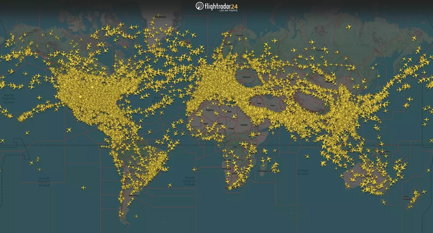
The image in question is from Flightradar24, a live air traffic tracking service which shows real-time positions of commercial aircraft flying around the globe, was posted to X on Thursday (19 June) along with the caption: "We are currently tracking more than 24,000 aircraft around the world.
"Based on current trends, it is likely that today will also set a daily record for most tracked flights ever."
Advert
On a first glance, the image simply looks like there are a whole load of planes soaring the skies, symbolised with yellow aeroplane icons which indicate active flights.

However, the entire Antarctic region (AKA the white landmass at the bottom of the world map) is empty of flights - bar one.
There is one single yellow plane icon in the bottom right-hand corner of the snap, near the edge of the Antarctic continent, specifically near the Antarctic Peninsula or the coastal region of East Antarctica.
Advert

Sharing their thoughts on the matter, one X user questioned: "What is this plane doing, and where does it come from?"
"Details of lower right corner aircraft?" wondered a second, while a third chimed in: "Heading to #Antartica?"
"Crazy one inside Antarctic Circle," chirped another.
Advert
A final X user pointed out: "What if in case any emergency happens? Not many airports or help nearby."
So, what could this particular plane be and why on earth is it down there - assuming it's not a technical glitch or mislocated icon.

Scientific or logistics flight
It's mostly like that this particular plane is a special-purpose flight supporting Antarctic research bases, e.g. carrying supplies, equipment, or personnel to/from a coastal research station.
Advert
Such flights often operate seasonally, mainly in the Antarctic summer, and use specialised aircraft or other ski-equipped planes.
Long-range survey or research mission
Additionally, aircraft sometimes conduct aerial surveys, climate monitoring, or wildlife studies over Antarctica’s coastal or oceanic regions.
These flights can appear briefly on radar if they are equipped with certain transponders.
Advert
Talking of interesting plane maps, Flightradar24 recently released an image of the dispersion of the commercial flights around the world, and a number of people have been unnerved by one creepy detail - namely that the map looked like a face due to the four very visible gaps.
Two gaps beside one another - one in Eastern Europe and another in East Asia - appeared to resemble two eyes, especially when placed just above another hole in the Middle East.
A third, considerably larger gap could be visible in the middle regions of Africa.
And if you haven't yet put these four empty spaces together, many believe they appear to resemble a skull.
Topics: Explained, Flight attendant, Plane Etiquette, Social Media, Travel, World News